
Scene Express and Nature View Express Samples
Scene Express can output to a variety of formats, each with their strengths and weaknesses. We offer several sample files, in several formats. Some samples are in VRML, which has the advantage of being a widely-adopted web standard, even though it’s not the highest performance or the most compact. Other files are in 3D Nature’s own NatureView format, viewable with our free NatureView Express viewer.
For VRML samples, you can either view the samples online, if you have a fast connection, or download them as a ZIP file and extract and view them off-line at your leisure. NatureView Express does not yet support viewing files straight from the server, so you must download the .NVZ file to your hard drive, and launch NatureView Express to open and view it.
NatureView Express
Viewer
You will need 3D Nature’s free NatureView Express viewer to view these scenes:
| NatureView Express (Windows) |
https://3dnature.com/wp-content/uploads/2020/12/NatureView-Full.zip NatureView Express is not currently available for any other OSes, but may be in the future. |
Scenes
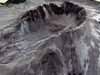
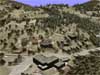
The Mount St Helens project is an educational geography and geology project to familiarize people with the local features of the Mt St. Helens volcano crater and immediate vicinity. It features 30m terrain data with 5m color imagery overlay. The imagery was synthesized from 30m color Landsat data and 1m monochrome USGS DOQQ data, using a new process from AlphaPixel. The Landsat color image is dated September 1997. This scene is 2.0Mb
Zipped: https://3dnature.com/wp-content/uploads/2020/12/MtStHelens.nvz
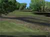
The Country Club golf course project, which exhibits high resolution foliage, shadows, ground texturing, 3D Objects with texturing, and sky with clouds. This scene is 8.4Mb (but is more detailed than the smaller VRML version, below)
Zipped: https://3dnature.com/wp-content/uploads/2020/12/GolfCourse.nvz
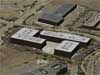
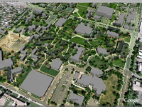
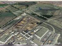
The Interlocken office park demo project demonstrates an urban area, with an airphoto drape, buildings made from Wall components, and scattered trees. Interlocken is the Colorado home to many technology companies such as Sun and ESRI. This scene is a little under 8Mb.
Zipped: https://3dnature.com/wp-content/uploads/2020/12/Interlocken.nvz
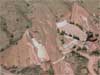
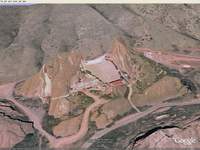
The Red Rocks Amphitheatre demo project demonstrates a mountainous area, with an airphoto drape, buildings made from Wall components, and scattered trees. The base terrain data is high-resolution LIDAR scanned, and the imagery is 1ft color orthophoto. This is a very high resolution scene. The tree locations are extracted from the orthophoto via an unsupervised classification scheme. The stage building was hand-digitized and extruded in VNS using the Walls component feature. Red Rocks is a famous performance venue, appearing in numerous music videos such as U2’s “Under a Blood Red Sky”. This scene is a little over 10Mb.
Zipped: https://3dnature.com/wp-content/uploads/2020/12/RedRocksLarge.nvz
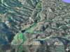
The Brook Forest demo project demonstrates a mountainous area with 10m USGS DEMs, a 1ft color orthophoto drape, buildings made from Wall components, and numerous trees. This is a very detailed scene. The tree locations are extracted from the orthophoto via an unsupervised classification scheme. The streets were carved into the DEM using Terraffectors, but the imagery was unaltered by this process. The buildings were hand-digitized and extruded in VNS using the Walls component feature. Colors of building sides were assigned based on ground truthing in the area. This scene is an excellent example of the classic urban-wildland interface issue. This scene is a little under 9Mb.
Zipped: https://3dnature.com/wp-content/uploads/2020/12/BrookForest.nvz
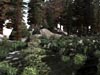
The Boulder Meadow demo project demonstrates a smaller artistic scene with lots of vegetation and natural texturing. This scene has over 1000 pieces of vegetation and a high-resolution texture map on the terrain. This is the exact same scene as in the Lightwave export of BoulderMeadow (below), for comparison. This scene is 12.4 Mb.
Zipped: https://3dnature.com/wp-content/uploads/2020/12/BoulderMeadowNV.nvz
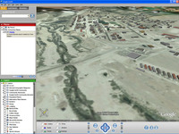
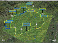
The Shawnee demo project demonstrates a mountainous area, with a merged Landsat/airphoto drape and 10m USGS DEMs. This is a less detailed scene, without trees or structures.`This scene was created for the Colorado regional website Pinecam.com, a community website for the mountainous areas west of Denver. In spring of 2004, a controlled burn in Shawnee went uncontrolled and threatened to become another very dangerous event. This project was created to help Pinecam members visualize the site of the fire. This scene is 1Mb.
Zipped: https://3dnature.com/wp-content/uploads/2020/12/Shawnee.nvz
Tips
When the NatureView Express viewer starts, press F1 to see the numerous key/mouse controls, and examine the variety of functions available on the button toolbars.
If you do have trouble viewing these files, check and make sure you have current, stable OpenGL drivers, and you aren’t simultaneously running any other OpenGL applications (like WCS or VNS) that will consume OpenGL resources.
Google Earth KML/KMZ Viewer
Viewer
You will need Google’s free Google Earth viewer to view these scenes. The latest version is Google Earth 5.0. Many of our samples were made for Google Earth 3.0 and will run under any version 3 or newer. A few new scenes are made specifically for newer versions to demonstrate new features. Every scene is labeled next to the download link to indicate which minimum Google Earth version it requires.
| Google Earth (Windows, MacOS X, Linux) |
| http://earth.google.com/download-earth.html |
Scenes
The Rocky Mountain National Park Flyaround project demonstrates flying around a mountaintop of existing Google Earth terrain.
Notes: This scene has no terrain or vegetation or image texture in it. It is simply to demonstrate VNS 3 Scene Express’ new capability to generate Google Earth 5 giuded Tours from VNS Animated Cameras. When you open this KML file, the 9-second tour will begin to play automatically even as the Earth loads. If you would like it to repeat, click the circled-arrows button at the right edge of the Guided tour toolbar in the lower-left of the Google Earth view.
This scene is 41Kb
GE5 KMZ: https://3dnature.com/wp-content/uploads/2020/12/ROMO.kml.zip
The Denver University project is a demonstration project to show how facilities can use interactive 3D visualization tools to familiarize people with their buildings, campuses and sites. This scene features half-meter color orthophotos combined with a building database and a vegetation survey all supplied by the Denver University Geography Department. This project contains several viewpoints, each created from a WCS/VNS Camera. All of the foliage is rigged with Actions (KML Descriptions) which when clicked, display GIS attributes indicating the species and condition of the tree in question. Actions are also employed on the various Camera and Videocamera symbols in the scene, which show georeferenced photos or webcam views respectively. Actions can be used to display images, text, video or any HTML from any scene object.
Notes: Vegetation is implemented as KML Icons. Google Earth seems to bias Icons slightly closer to the camera when deciding if they are or are not visible behind structures like buildings. This results in vegetation sometimes being visible through buildings. Also, Icons maintain their apparent screen size no matter how close or far away you are from them, so they only properly represent their real-world sizes at a certain range of distances. This size and therefore the useful viewpoint range can be controlled during export from Scene Express.
This scene is 3.1Mb
GE3 KMZ: https://3dnature.com/wp-content/uploads/2020/12/DU.kmz.zip
This project contrasts the detail available in a stock Google Earth scene of a remote area, with what can be assembled from public data sources. We have constructed a scene containing 1m color orthoimagery from the 2005 NAIP orthophoto project, as well as buildings created from footprints digitized from the orthophoto. Building height attributes were randomly assigned based on building area and adjustable weights. Buildings were then created from this GIS database with VNS’s Walls component. Roof colors were also randomly based on several typical colors taken from the actual orthophoto.
Notes: The orthoimagery is split into multiple tiles by Scene Express, to reduce memory consumption and improve performance in the viewer. This results in a slight seam being visible from distant viewpoints, but is not present up close.
This scene is 3.7Mb
GE3 KMZ: https://3dnature.com/wp-content/uploads/2020/12/Fairplay.kmz.zip
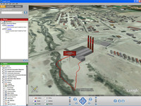
The PowerPlant add-on scene is intended to be used with the Fairplay scene above. It depicts a (fictional) proposed power plant project. By placing the PowerPlant in a second KMZ file, it (or other variants like it) can easily be turned on and off individually or in combination to show multiple alternatives, or before and after. The KML draw order (controllable during export) is set higher in this file, to ensure it lays over top of the underlying Fairplay file. The drape image uses Alpha blending to smoothly feather out the imagery in this file into whatever lies below it in draw order. The building is a 3D object that comes with WCS/VNS. The road and parking lot are made with the Terraffectors and vector-bounded Ecosystems features. The Possible Contamination Plume outline is a GIS polygon that was styled and exported and the Possible Contamination Plume sign is a VNS Label.
This scene is a little under 450KB.
GE3 KMZ: https://3dnature.com/wp-content/uploads/2020/12/PowerPlant.kmz.zip
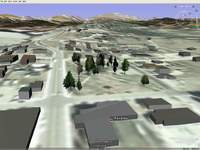
The Google Earth 4 Park add-on scene is intended to be used with the Fairplay scene above. It adds several park trees to the scene. By placing the Park in a second KMZ file, it (or other variants like it) can easily be turned on and off individually or in combination to show multiple alternatives, or before and after.
Notes: The trees are “Crossboards” — made of two textured polygons placed in an X arrangement (viewed from above). Google Earth 4 does not support billboarding of 3D objects, so this is the best available option. Also, current releases of GE4 do not seem to properly z-sort polygons that have transparent textures (like our trees) resulting in some display artifacts on trees. 3D Nature has verified that our transparent COLLADA tree objects do work properly in other COLLADA-supporting applications, so this is a fix that will have to be made by Google. There is one COLLADA tree object per species, and these are instanced into the scene multiple times in the KML file to reduce scene size and ensure each tree floats properly on the GE ground. Each of the four tree species images is 512×512 pixels, which is the reason for the large file size.
This scene is a little over 1.7Mb.
GE4 KMZ: https://3dnature.com/wp-content/uploads/2020/12/FairplayPark.kmz.zip
The Ididaride 2006 trail map shows the route of the Ididaride 2006 Adirondack Bike Tour, noting start and finish lines, points of interest as well as route slope (climb/descend) along the entire course. Visual Nature Studio’s extensive cartography features were used here as well as for other mapping projects for the same event. Each numbered signpost is provided with an Action that displays the event’s web site URL when clicked upon. Actions (KML Descriptions) can be used to display images, text, video or any HTML from any scene object. This scene was built by James Zack.
This scene is a little over 5.6Mb.
GE3 KMZ: https://3dnature.com/wp-content/uploads/2020/12/Ididaride2006.kmz.zip
The Google Earth 4 Red Rocks LIDAR demo shows off the ability to convert terrain into 3D geometry for display (since KML doesn’t really provide for the functionality of adding/replacing terrain). New in GE4 is the ability to support textured COLLADA 3D objects, which we are employing to place the pseudo-terrain. Here, a small patch of very-high-resolution LIDAR-scanned terrain is inserted into the Google Earth environment to demonstrate the lack of detail in the base terrain model. We are using the same USGS Urban Areas hi-resolution orthophoto imagery that Google themselves uses in this area. Google has slightly altered the coloration in their images to reduce the excessive yellow color — our image is uncorrected. This allows you to see where our data ends and Google’s begins. Note that the Scene Express terrain and imagery data line up exactly with Google’s base data. Notes: This scene can stall GE4 for a short time when it is loaded.
This scene is about 574KB.
GE4 KMZ: https://3dnature.com/wp-content/uploads/2020/12/Ididaride2006.kmz_.zip
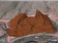
The Google Earth 3 Red Rocks LIDAR demo shows off the ability to convert terrain into 3D geometry for display (since GE 3’s KML doesn’t really provide for the functionality of adding/replacing terrain). In Google Earth 3, this added geometry cannot have any texturing, only a solid color (which is controlled by the user). Here, a small patch of very-high-resolution LIDAR-scanned terrain is inserted into the Google Earth environment to demonstrate the lack of detail in the base terrain model.
This scene is about 450KB.
GE3 KMZ: https://3dnature.com/wp-content/uploads/2020/12/RedRocksLIDAR.kmz_.zip
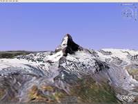
The Google Earth 4 Matterhorn demo also shows off the ability to convert terrain into 3D geometry for display. Here, a small patch of 30m DEM data is inserted into the Google Earth environment to demonstrate the lack of detail in the base terrain model. Since no higher-resolution imagery was available that permitted free redistribution, VNS’s Snow, texturing and fractal subdivision features were used to improve the look of the relatively-coarse imagery and introduce more apparent detail and variation. This project was done in response to Ogle Earth demonstrating the poor resolution of GE’s basic terrain. Try toggling the KML file on and off in GE’s left Sidebar to compare the before and after terrain quality.Notes: This scene can stall GE4 for a short time when it is loaded.
This scene is about 1MB.
GE4 KMZ: https://3dnature.com/wp-content/uploads/2020/12/Matterhorn.kmz_.zip
The Google Earth 4 Sollenau Highway demo shows off applications of VNS, Scene Express and Google Earth in civil engineering and highway design. This scene is part of a planned motorway-bypass south of Vienna. A textured CAD model of the interchange is integrated into the environement, along with nearby buildings and vegetation. Due to the low resolution of Google’s imagery, a high-res color commercial orthophoto is used to texture the surrounding terrain and building rooftops. This project was a trial to evaluate the the potential of Scene Express with Google Earth, and the client was very happy with the outcome. Notes: Due to the speed of loading numerous identical objects (trees) in the current release of Google Earth, the Trees and Woods KML folders are disabled be default. Turn them on in the left Sidebar to see the vegetation.
This scene is about 4.3MB.
GE4 KMZ: https://3dnature.com/wp-content/uploads/2020/12/B17_Sollenau.kmz_.zip
Tips
If you do have trouble viewing these files, check and make sure you have current, stable OpenGL drivers, and you aren’t simultaneously running any other OpenGL applications (like WCS or VNS) that will consume OpenGL resources.
Lightwave3D
Viewer
These scenes are designed to run in Lightwave 7.5 or newer. You will need the Happy Digital HD-Instance plug in for Lightwave to render these samples. A Demo version of HD-I is available here. HD-Instance is necessary for Lightwave to efficiently handle thousands of billboards of foliage (or any other object). 3D Nature offers a bundled discount on HD-Instance that is almost half-off regular HD-I price.
Scenes

The Boulder Meadow project, which exhibits high resolution foliage, shadows, ground texturing, and sky with clouds. This scene is about 12Mb.
Zipped: https://3dnature.com/wp-content/uploads/2020/12/BoulderMeadowLW.zip
Tips
The demo version of HD-Instance can only render 8 billboards (trees and plants) at high-resolution, or 1024 billboards at 320×240 resolution. We recommend that users with the Demo version of HD-I render this scene at 320×240. If you already have the full version of HD-Instance, you can try it at full resolution.
VRML
Viewer
You will need a VRML browser plug-in to view these scenes:
| Xj3D (Java, all platforms) | Orbisnap (Windows, Linux, Mac, Solaris) | Parallel Graphics Cortona: (Mac or Windows) |
| http://www.xj3d.org/ | http://www.orbisnap.com/index2.html | http://www.parallelgraphics.com/products/cortona/ |
VRML Viewers are available for other OSes as well.
Scenes

The Country Club golf course project, which exhibits high resolution foliage, shadows, ground texturing, 3D Objects with texturing, and sky with clouds. This scene is about 5Mb
Live: https://3dnature.com/wp-content/uploads/2020/12/Country_Club_VRML.wrz_.zip
Zipped: https://3dnature.com/wp-content/uploads/2020/12/sx-cc-vrml.zip
The Mount Hood demo project demonstrates a large region, with an airphoto drape, and multiple levels of detail. This scene is a little over 4Mb.
Live: https://3dnature.com/wp-content/uploads/2020/12/MountHood_VRML.wrz_.zip
Zipped: https://3dnature.com/wp-content/uploads/2020/12/sx-mh-vrml.zip
Tips
Astute observers may notice a series of subterranean inverted V shapes. These are normal — these are part of the tile Level of Detail system we use to dynamically switch between tiles of different resolution without gaps or seams being visible.
If you do have trouble viewing these files, first check and make sure the whole file has downloaded (or try the ZIPped version viewed locally). Then make sure you are running a modern VRML browser, and finally check and make sure you have current, stable OpenGL drivers. Please remember that some VRML navigation schemes can be awkward to learn the first time. This has nothing to do with Scene Express, but is just part of the VRML standard.
OpenFlight
Viewer
You will need an OpenFlight-compatible Viewer or Image Generator to view these files. Most OpenFlight users already have such software in place, but if you do not, the OpenSceneGraph project offers a free viewer that can view OpenFlight files, among others.
These samples are generally smaller and lower-detail than might be used in production output, in order to keep download sizes down. Also, they only exhibit basic terrain and texturing, which can be handled by almost all OpenFlight viewers. Scene Express also has the ability to export billboarded foliage and textured 3D objects, but not all viewers handle this successfully. Contact 3D Nature for questions about interoperability with your particular Image Generator software.
| OSGViewer (Windows, Linux, others) |
| http://openscenegraph.alphapixel.com/osg/downloads/free-openscenegraph-binary-downloads |
Scenes
The Boulder project includes detailed terrain with a high-resolution ortho image drape. This scene is about 23.4Mb
Zipped: https://3dnature.com/wp-content/uploads/2020/12/Boulder_OF.zip
The Peaceful Valley scene demonstrates terrain and image draping. This scene is about 10.7Mb.
Zipped: https://3dnature.com/wp-content/uploads/2020/12/OF_PV.zip
Tips
Astute observers may notice a series of subterranean inverted V shapes. These are normal — these are part of the tile Level of Detail system we use to dynamically switch between tiles of different resolution without gaps or seams being visible.
If you do have trouble viewing these files, first check and make sure the whole file has downloaded. Then make sure you have current, stable OpenGL drivers. Please remember that some navigation schemes can be awkward to learn the first time. This has nothing to do with Scene Express, but is part of the viewer you choose to utilize.
STL and Rapid Prototyping VRML
Viewer
The actual STL format can only specify geometry, but not color or texture. The VRML-for-STL variant is used for models that need color and texture. Contact 3D Nature for questions about your particular application.
You will need an STL-compatible Viewer or a VRML viewer to view these files. Most Rapid Prototyping users already have such software in place, but if you do not, here are some viewers you can try:
| STL viewer | ||
| http://sourceforge.net/projects/viewstl/ | ||
| VRML viewers | ||
| Xj3D (Java, all platforms) | Cortona: (Windows, iOS) | |
| http://www.xj3d.org/ | http://www.cortona3d.com/cortona3d-viewers | |
Scenes

NorthTableMtn (STL)
This Golden, Colorado project includes detailed 10m terrain. The STL format does not include color or texturing data. This scene is about 9.5Mb (1.4Mb zipped)
Zipped: https://3dnature.com/wp-content/uploads/2020/12/NorthTableMtn_10m.zip
This file is the same area as NorthTableMtn (above), but output in VRML-for-STL, with a color texturemap. This model is configured for the proper dimensions for fabrication on a Z-Corp Z406 machine. This scene is about 3.2Mb (2Mb zipped).
Zipped: https://3dnature.com/wp-content/uploads/2020/12/NorthTableMtn_25m-VRML_STL.zip