3DNature

3D Landscape Design & Visualization Software published and supported by AlphaPixel

Menu

Foresters

Visualization for Professionals

Forestry

Pre-Cut Visualization Cherylin Drew
Harvestable Timber Visualization Ken Fairhurst
Forestry Visualization Gary Huber
Forest Cut Planning Eric Crews

VNS is USDA Forest Service Blanket Approved. Contact us for details.

The Forestry Edition is made for forestry! Click here to find out more.

Forestry Show Reel

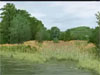
This collection of images and animations was put together for the Society of American Foresters event. Works were contributed by 3D Nature customers from around the world.

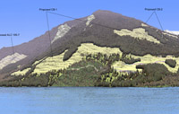
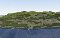
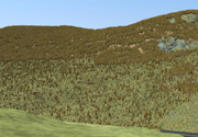
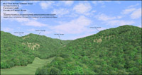
Big Horn Forest Case Study

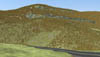
This is a case study write up of a beetle kill mitigation project in the Big Horn National Forest in Wyoming. .

Whether you are creating visualizations for approval of a new harvest plan, exploring the options for forestry work, researching the ecological effects of a kill area mitigation or making educational materials to share with the public, 3D Nature provides tools that are designed to be used in all Forestry applications.

  • Take the chore out of visualization with VNS 3’s process improvements and tools. Streamline data flow, reduce file conversion, automate data integration and eliminate redundant changes and updates.
  • Use the intuitive and flexible Import Wizard to assimilate your terrain data from over twenty supported formats. Crop, shift, scale, adjust and tile during import. For contour lines, TINs or control points, quickly grid regularized terrain meshes straight from the Import Wizard.
  • No need to reproject your data before importing it, VNS natively understands over 30 different projections and over 300 datums. Mix and match data in different projections and datums with ease, VNS will ensure they line up properly.
  • Import landcover information in raster or vector form. Choose relevant shapefile attributes (species name, density in stems per unit area, height) to be used later. If the landcover data are likely to be changing, flag the shapefile for Dynamic ReImport and VNS will reload a fresh copy every time the Project loads.
  • Create an Ecosystem Component for each major species or species mix. Add representative foliage images – we supply hundreds. Don’t see the perfect one? They’re easy to make from digital images of tree specimens. Create a quick Search Query to instruct VNS to look at polygon attributes and identify which correspond to each species. Create a Thematic Map that draws directly from height classification attributes and communicates them to the Ecosystem. Add unit or notation conversion factors if necessary. Add another Thematic Map to connect up Density information. That’s it! Height and Density Thematic Maps are often common to all Ecosystems, avoiding duplicate effort. Combine multiple subdominant species into each Ecosystem and control their height and density with attributes.
  • Choose a Viewpoint interactively, moving the virtual camera around with the mouse. Or, copy from an imported position or path with the Path/Vector Transfer tool. Fly down a road centerline. Recreate the perspective from a GPS-surveyed location. Explore known and unknown vantages. View from overhead or person height. Turn on RealTime foliage and see every tree and plant in realtime as you move around your scene.
  • A forestry visualization is more than just stems of vegetation. Define a typical understory vegetation and ground texture for each Ecosystem if appropriate. Add water bodies like lakes and streams using the same attribute-driven methodology to specify their locations and water levels. Drop in one of several provided Road Components simply by specifying a path or polygon. Create your own custom road definitions complete with texturing, striping, even blend in shoulders with weeds. Make the visualization sing with realistic clouds: puffy, thick, thin, light, dark or colorful. Add fog, mists and distant haze.
  • There’s never just one option, and frequently it falls to visualization to depict the multitude of potential courses of action. Encompassing the numerous variations, ensuring they all stay current to common changes and updating them all when the base data is updated could be a herculean task. Scenarios in VNS coordinate the task of orchestrating multiple variations of a theme within a single easily managed project file. Scenarios can dynamically show or remove elements from a visualization for a particular rendering. Keep the common elements together as you add or remove proposed cutblocks and roads, relocate polygons and redesign perimeters, change lighting conditions and make long-term alterations to the landscape.
  • Communicate the proposal by choosing the most expressive medium for the project. Create still images of critical vantage points, large posters contrasting alternatives, animated presentations of before and after, fly-throughs, fly-overs and drive-by movies. Interact with panoramic renderings showing every angle from one or more viewpoints. Depict the same proposal, summer and winter, morning and evening, leafed or bare. Produce everything from a single unified project!
  • Add extra defining information to rendered output with Post Processing. The Text and Graphic Overlay features can add the professional finishing touch to every visualization. Add a company logo graphic in one corner of the output. Overlay a copyright notice, or mark not-for-release images as such. The Dynamic Text Overlay feature can put updated constantly changing information about current camera/observer position right onto the animation as a heads-up-display of position, elevation, heading/bearing and more. VNS can automatically annotate each image with the Project name, Camera name and Job/Options name, allowing easy identification of which proposal, variation and viewpoint the image represents.
  • Creating high resolution posters and detailed animations on a production schedule can tax the computing abilities of the fastest computers. Stay ahead of deadlines by harnessing the power of all available computers during down times with the SuperConductor render farm controller and license-free Render Engine capability included with every VNS. Buy one license of VNS, get the ability to render on many networked clients overnight or on weekends when they’re idle. Deliver more, in less time.
  • VNS 3 has many tools to save you time. If you’ve made something useful, chances are you’ll use it again. Minimize redundant work by saving reusable Components for use in future projects. Encapsulate whole schema (Thematic Maps, Search Queries Dynamically linked to Components to define how your data should be interpreted) into a standardized Template. Now, creating a new visualization using the same rules is as quick and easy as inserting new terrain and landcover data files into a Template-derived project. All the pre-made Components and rule bindings are picked up automatically. Templates can be created and maintained by a VNS-trained expert, but utilized on a daily basis by less experienced production operators.
  • Design your scene and then export it using Scene Express for interactive realtime exploration.

Visual Nature Studio and World Construction Set satisfy the needs of Forestry and Resource Managers at two different levels. Visual Nature Studio gives you greater power, precision and flexibility plus some extra features that WCS doesn’t have. World Construction Set is great for concept development where scientific and geographic accuracy are of lesser importance. Both programs give you the ultimate in artistic expression and photo-realism. If you would like to learn more about the differences between WCS and VNS visit our Product Comparison Page.

If you wish to further discuss how WCS or VNS can work for you please feel free to drop us a note or call our Sales office at (303) 659-4028.

Place an order via our secure web server.

Scroll to top